
Thousands of Americans living along Alaska’s rugged coastline scrambled to safety on Wednesday after a strong 7.3 magnitude earthquake shook the region and set off an urgent tsunami warning.
At 12:38 p.m. local time (4:30 p.m. ET), the US Geological Survey (USGS) reported the quake’s epicenter beneath the Pacific Ocean, southeast of Sand Point near the Shumagin Islands, just south of the Alaska Peninsula.
Residents from Kennedy Entrance near Homer all the way to Unimak Pass near Unalaska were immediately alerted by blaring sirens and emergency phone warnings urging swift evacuation to higher ground.
“We saw bumper-to-bumper traffic as people rushed to leave the spit,” said Rachel Lord, mayor of Homer, describing the chaotic but determined exodus.
Officials also warned of possible tsunami waves threatening parts of the eastern Aleutian Islands, the Alaska Peninsula, and Kodiak Island, with some areas expected to feel the impact first.
Dramatic Photos Show Eerily Empty Coastline as Tsunami Threat Looms After Alaska Quake
Heart-stopping images revealed a hauntingly barren coastline where the ocean had mysteriously receded—an ominous sign that a tsunami could strike at any moment.
David Snider, tsunami warning coordinator at the National Oceanic and Atmospheric Administration (NOAA), confirmed a tsunami had been generated by the quake, causing minor waves that raised water levels by about three inches. Speaking to KTUU, he reassured residents:
“A tsunami was generated by this event, but no longer poses a threat. Some areas may continue to see small sea level changes.”
The initial tsunami warning was issued moments after the 7.3 magnitude quake struck. About 90 minutes later, the alert was downgraded to an advisory, and at 12:45 p.m. local time (6:45 p.m. ET), it was officially canceled. Despite this, authorities urged continued caution through Thursday, warning that unusual waves might persist for roughly 24 hours.
Panic swept through coastal communities as Kodiak High School and North Star Elementary were opened as emergency shelters. In a tense video shared on X by a Seward resident, who had just returned to Alaska after 25 years away, she and others can be seen hastily retreating to higher ground. “Just pray we don’t get waved,” she says nervously before ending the clip.
Since Wednesday’s quake, the Alaska Earthquake Center has recorded over 20 aftershocks, the largest measuring magnitude 5.2. Seismologist Michael West told Fox Weather, “The entire southern coast of Alaska is a gigantic earthquake zone. Four out of five earthquakes in the United States happen in Alaska.” He added, “While earthquakes here are frequent, events of this size are rare, and many are too small to feel. Early signs suggest we’re on the lucky side today.”
Meanwhile, the National Weather Service quickly confirmed that US states west of Alaska, including Oregon and Washington, are not at risk from this event.
The tsunami advisory covered a stretch of roughly 700 miles—from Unimak Pass near the eastern Aleutian Islands to about 40 miles southwest of Homer. Kodiak, with a population of around 5,200, was among the largest communities in the affected zone. King Cove, a small coastal town of roughly 870 people on the southern Alaska Peninsula, issued an evacuation advisory for residents in low-lying areas.
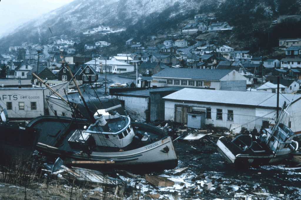
Alaska’s history with powerful earthquakes runs deep. The last quake close in magnitude struck on June 10, 1996, near the Andreanof Islands in the Aleutian chain, registering 7.2. But the most catastrophic remains the Great Alaska Earthquake of 1964, a massive magnitude 9.2 tremor felt as far away as Seattle. That quake unleashed devastating tsunamis that ravaged shores across Hawaii, California, Oregon, Alaska, and even reached Japan.
Please SHARE this article with Family and Friends and let us know what you think in comments!