
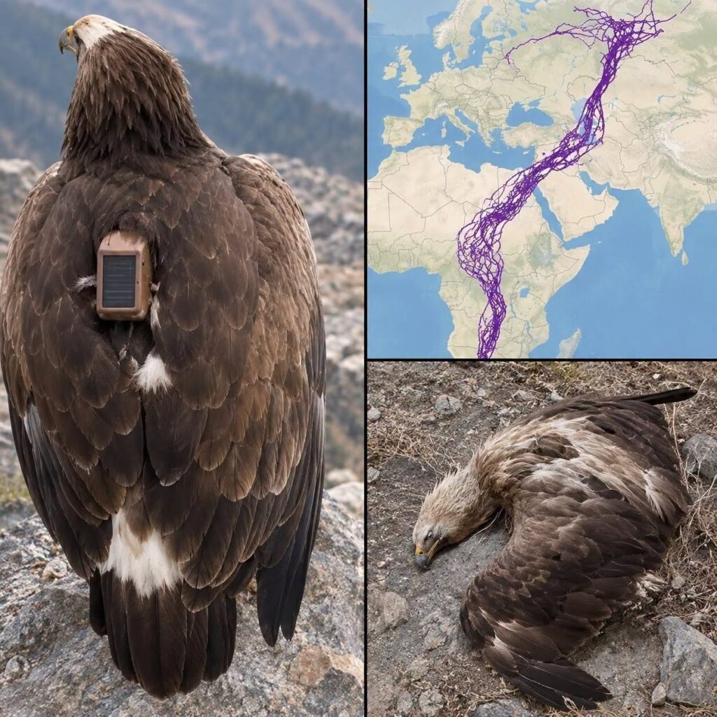
Scientists Tracked Eagles Across Continents—And Their Extraordinary Journeys Revealed Nature’s Hidden Secrets
A remarkable collection of eagle migration routes once left people fascinated by what appeared to be an impossible journey. The complicated lines crossed countries, deserts, mountains, and coastlines, revealing a world of movement that humans rarely get to witness. But behind the viral story was an even more compelling scientific truth: migrating eagles are remarkable navigators whose journeys are shaped by wind, geography, survival instincts, and an extraordinary ability to respond to changing environments.

Imagine standing on a remote hillside just as the morning sun begins to rise.
The air is cool, the landscape is quiet, and somewhere high above the ground, a magnificent eagle spreads its wings. With barely a movement, it catches a rising current of air and begins to climb.
Within minutes, the bird becomes little more than a dark silhouette against the sky.
To someone watching from below, there is no way to know where it is going.
Perhaps it will travel only a few miles before finding food. Perhaps it will cross a mountain range, follow the edge of a desert, or continue toward a distant coastline. If the season is changing, it may be beginning a journey that will eventually carry it across national borders and enormous stretches of unfamiliar territory.
For centuries, much of this movement remained hidden from human observation.
People watched birds appear in spring and disappear in autumn, but the details of their journeys were often mysterious. Where did they spend the intervening months? What guided them through unfamiliar landscapes? How did they overcome natural obstacles without maps, roads, or human-made navigation systems?
Modern tracking technology has begun answering these questions.
And in doing so, it has revealed that migration is far more complicated than a simple journey between two points.
One widely shared eagle migration map became particularly famous because of the extraordinary network of routes displayed across a vast region.
The image was often described as the twenty-year journey of a single eagle.
In reality, fact-checking traced the map to movements of multiple tracked eagles over a much shorter period. Yet the truth remains fascinating. Each line represents an animal making its way through a world of changing conditions, encountering challenges that cannot be fully understood from a static map.
The scientific story behind such journeys is not about one bird mysteriously breaking every known rule of migration.
It is about how much remains to be learned from the astonishing movements of wild animals.
The Mystery Behind a Map That Captured the World’s Attention
When the eagle migration map circulated online, it immediately attracted attention.
The routes formed a dense network of lines extending across large geographical areas. Instead of resembling a neat highway connecting northern and southern destinations, the tracks curved, diverged, overlapped, and appeared to move in unexpected directions.
For many viewers, the image raised an intriguing question.
Why would a bird travel such an enormous distance without following a straightforward route?
Some lines appeared to bend around geographical obstacles. Others extended through areas that looked empty on an ordinary political map.
To someone unfamiliar with migration science, the movements might have seemed almost random.
But there is a fundamental difference between a route appearing unpredictable to humans and a route being biologically meaningless.
A political map shows countries, borders, cities, and roads.
A migrating eagle experiences an entirely different landscape.
Its world is shaped by rising air, shifting winds, mountain slopes, available prey, weather systems, and suitable places to rest.
The shortest route on a map may not be the easiest route through the sky.
A journey that looks unnecessarily long may allow a bird to avoid exhausting conditions. A curved path may take advantage of favorable winds. A pause in an apparently unremarkable location may correspond to an important feeding area.
This distinction is essential.
Scientists do not interpret animal movement simply by looking at lines on a map. They compare movement records with environmental information, individual behavior, and the physical challenges encountered along the route.
And even then, some questions remain unanswered.
The famous eagle map illustrates both the power and the limitations of tracking technology.
It can tell researchers where a bird traveled.
Understanding precisely why the bird made every turn is a much more demanding task.
How Scientists Follow Birds Across Thousands of Miles
The ability to track a wild eagle would have seemed almost magical to naturalists living only a century ago.
Early migration research depended heavily on observation, recovered bird rings, reports from distant locations, and careful comparisons of seasonal populations.
These methods produced valuable discoveries, but they left enormous gaps.
A bird might be marked in one country and later recorded thousands of miles away. Researchers could identify two locations, but the actual journey between them remained largely unknown.
Satellite telemetry helped transform this field.
Today, scientists can attach carefully designed tracking devices to suitable birds under approved research protocols. Depending on the equipment, these devices can record locations, movement patterns, altitude, and other information.
Some transmitters communicate through satellite networks. Others use mobile communication systems when coverage is available.
The resulting data can reveal where birds travel, how quickly they move, where they stop, and whether they return to particular regions.
Instead of studying only the beginning and end of a migration, researchers can examine sections of the journey in remarkable detail.
Nevertheless, attaching a tracker is only the beginning.
Researchers must consider the bird’s welfare, the weight and fit of the equipment, the transmitter’s lifespan, and the reliability of the collected information.
Tracking records may contain gaps because of limited battery power, communication failures, difficult terrain, or periods without a usable signal.
A sudden change in recorded location does not automatically indicate unusual animal behavior. Data quality must be examined before scientists draw conclusions.
But when reliable movement records are combined with meteorological observations and ecological research, they create an extraordinary window into the lives of migratory birds.
A collection of geographical coordinates becomes something far more meaningful.
It becomes evidence of how an animal interacts with the natural world.
A Journey That Does Not Always Follow the Shortest Route
One of the most surprising lessons from bird migration research is that efficiency does not always mean traveling in a straight line.
Imagine two routes to the same destination.